Social Studies Land
Tuesday, May 27, 2014
What A Year
Wow folks time has really flown. I can't believe that we are finishing up the school year. What a great year from learning about the earth's basic geography to studying the ancient civilizations of Latin America. We sure have come a very long way. Let's remember to keep selling those rainforest tickets this week!
Tuesday, November 5, 2013
Crust and Mantle....Crust and Mantle
Today we discussed how we can come to a better understanding of our planet. One way is to simply look at the earth from afar. We can see three main parts of the earth, the actual land, oceans, and air that makes up the atmosphere. But what about what is lying under the surface? How can we discover what is there? Get out a shovel and dig? That would be pretty difficult to achieve. A better way would be to simply look for clues about what might be underneath. If we look closely at the Ring of Fire around the pacific we will notice lots of volcanoes and earthquakes which provide us with clues about the inside of earth. According to the clues the inside must be hot and it must have parts that move. In fact there are 4 layers of the earth, three of which most of us will never see. The layer on which we live is called the crust. Underneath that is the mantle which is a thick hot rocky layer. The core is made of two parts a solid metal center and a liquid outer core. Check out Mr. Lee's song to help you learn the layers of the earth.
Thursday, October 24, 2013
Earth...I Like the Way You Move!
Patriotism Essay
Our students just recently completed an exercise of the writing process that asked them to discover what patriotism really meant to them. Students were challenged to figure out they can best show patriotism in their community and to reflect on great patriots of the past. This essay will be submitted to the VFW's national Patriot's Pen Essay competition and a local winner will be read at our Veterans Day assembly in November.
Thursday, September 26, 2013
The Geographer's Tools
Time has gotten away from me in and this blog has fallen behind in keeping the blog update. The past few days have been a bit of a blur. Earlier this week we wrapped up the first section of chapter one and finished it out with a quiz on Tuesday. After the quiz we have began our journey into exploring the geographers tool box. Our exploration has checked out the strengths and weaknesses of maps and globes. Not only did we learn what a map projection is, but also how they are made and why every single map has inaccuracies because of distortion. In order to demonstrate why distortion happens we tried to flatten out an orange peel and learned that stretching and tearing always occurs...this is distortion. The three major types of projections that we must remember are the mercator projection, the equal area projection, and lastly the Robinson projection.
Tuesday, September 17, 2013
National Constitution Day
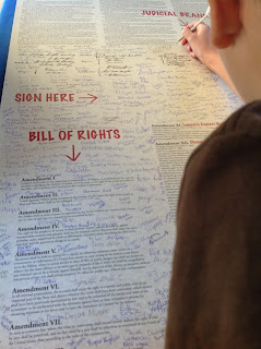
Today we celebrated the birthday of the US constitution by honoring the document that laid the foundation for the creation of our country. We learned that the constitution outlines the powers of the president, congress, courts, and most importantly the people. What makes our government and country exceptional is the fact that our nation was founded around limited government and giving power to the people rather than its leaders. In honor of this tradition each class also got the opportunity to vote for their student council representatives. Later we had the chance to sign a large copy of the constitution and visit with the likes of Uncle Sam, James Madison, and George Washington.
Monday, September 16, 2013
Where In the World Is......Justin Bieber
Class today was focused on determining how longitude and latitude help us locate places on the earth. It is best to remember that Latitude lines measure distance north and south of the equator while longitude lines measure distance east and west of the prime meridian. Using this imaginary grid we can located any place on earth, celebrity, or car driving down the highway while using a GPS. Students were also reminded that scale tells us how distance on a map relates to distance in real life and the importance of a compass rose and map key. Much to the dismay of many students we used Justin Bieber's head to practice determining longitude and latitude Students were given a brief practice worksheet to complete for homework.
Subscribe to:
Comments (Atom)


